HIKING ROUTES
ENJOY MONFRAGÜE
Walk surrounded by nature and discover the routes that everyone is talking about
Live the experience
Upon arriving at the Palacio Viejo, you will soon realise that you are in a singular landscape, set in the dehesa and the unique ecosystem of the Monfragüe National Park: you will live the experience of being in a nature reserve and a special bird protection area.
shrubs such as heather, kermes oak, rockrose, rosemary and lavender. You will be surprised to see deer, genets, badgers, lynxes, wild cats, martens, otters, snakes, tortoises, bats, to name a few. Birds nest in the cliffs along the Tagus, and if you look up you may spot the black vulture, the imperial eagle, the owl or the black stork. When night falls in Monfragüe, a blanket of stars spreads over the National Park. Thanks to the brightness of the sky and the low light pollution, it has been a Starlight Tourist Destination in Extremadura since 2016.
Vive la experiencia
Cuando llegues al Palacio Viejo verás que te encuentras ante un paisaje singular, rodeado de dehesa y el ecosistema único del Parque Nacional de Monfragüe: vivirás la experiencia de estar inmerso en una Reserva de la Biosfera y en zona ZEPA (Zona Especial de Protección de Aves).
Aquí encontrarás árboles cómo el alcornoque, el quejigo, el acebuche y la encina y arbustos como brezos, coscojas, jaras, romeros y cantuesos. Te sorprenderá ver ciervos, jinetas, tejones, linces, gatos monteses, garduñas, nutrias, culebras, galápagos, murciélagos… En los acantilados del Tajo anidan las aves, si levantas la vista, es fácil ver al buitre negro, el águila imperial, el búho o a la cigüeña negra. Cuando cae la noche en Monfragüe un manto de estrellas se extiende por el Parque Nacional, su excelente calidad del cielo y su escasa contaminación lumínica lo convierten en Destino Turístico Starlight de Extremadura desde 2016.

How to get there
You can get to the park by car, bus or train.
Car: the EX-208 road goes as far as Villarreal de San Carlos, a village within the park.
Bus: there are buses from Torrejón and Madrid that stop in Trujillo, Plasencia and Villarreal.
Train: there are trains from Madrid, Seville, Badajoz, Lisbon, Cáceres and Plasencia to Monfragüe Station, which is located 18 km from Villarreal de San Carlos and 5 km from the Monfragüe campsite.
What to visit
We recommend visiting bird of prey viewpoints such as the Salto del Gitano, climbing up to Monfragüe Castle, or walking to the Portilla del Tiétar. If you want to go bird-watching, you can best go to the Arrocampo bird park in Almaraz, and if you want to take a refreshing dip in natural pools, visit the Garganta de los Infiernos (Hells Gorge) in La Vera.
The best way to find out more about the park is to visit the information and tourism centre in Torrejón el Rubio, both for cycling and hiking routes.
ON FOOT THROUGH MONFRAGÜE
Hiking routes
We suggest three routes to do on foot. Each has a different colour and a different degree of difficulty.
DISTANCE: FROM 10,5 TO 16 KM // DURATION: FROM 3 TO 6 HOURS
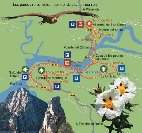
The RED route: from Villarreal to Monfragüe Castle
This is the longest route in the park. You will follow the cattle track (cañada real), a wide road that crosses the park from north to south. Herds of goats, sheep and cows pass through here to go north in summer and south in winter, in search of the best pastures. This activity, called transhumance, used to be very important in Spain. You will discover the huts (chozos) of Villarreal, made of stones and with a wooden roof, where the transhumance herdsmen rested. You will cross the Tagus river over the Puente del Cardenal (Cardinal’s Bridge), built in 1450.
The red route in detail
At the Fuente del Francés, a fountain, you can refresh yourself and take a rest in the picnic area. You’ll see the house of the peones camineros, where the people in charge of maintaining the Camino Real, an old road that linked Extremadura with Castile, used to live. If you are feeling adventurous, you can climb up to Monfragüe Castle, which has the best views of the park. The chapel houses the figure of Our Lady of Monfragüe. The red route also takes you to a cave with drawings depicting people and hunting scenes, made by the first inhabitants of the park. Prehistoric men and women lived in caves like this one. It is possible to visit the cave, but only accompanied by a guide. One of the most spectacular spots in Monfragüe is the Salto del Gitano, a 300 metres high cliff which towers over the Tagus River. From the viewpoint you can observe the different birds that fly over the area.
Part 1
FROM VILLARREAL TO THE FUENTE DEL FRANCÉS // DISTANCE: 3 KM // DURATION: 35 MINUTES ON FOOT // DIFFICULTY: DESCENT ALONG THE GENTLY SLOPED CAÑADA REAL
You can go from Villarreal to the Fuente del Francés by car or on foot. If you go by car, take the EX-208 road (2.5 km). If you go on foot, take the Cañada Real until you pass along the huts of Villarreal. Go down the cattle track to the Puente del Cardenal. If the bridge is covered with water due to the risen levels of the Alcántara reservoir, you must continue along the road and cross over the Puente Nuevo. After crossing the bridge, take the old road that continues along the Cañada Real, until you reach the Fuente del Francés.
Part 2
HUERTO DEL ALMEZ // DISTANCE: 0,50 KM // DURATION: FROM 15 TO 30 MINUTES // DIFFICULTY: EASY HIKE
This is a small circular route for those who prefer a shorter hike. From Villarreal, take the Cañada Real until you pass the huts of Villarreal. You can rest in the shade of a very large hackberry tree.
Part 3
FROM THE FUENTE DEL FRANCÉS TO MONFRAGÜE CASTLE // DISTANCE: 2 KM // TIME: FROM 45 TO 60 MINUTES // DIFFICULTY: UPHILL PATH THROUGH THICK VEGETATION
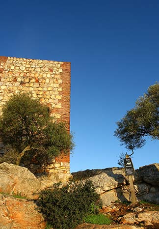
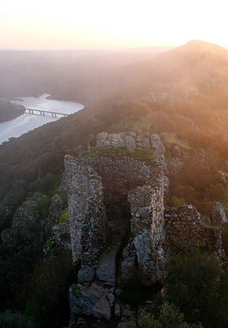
From the Fuente del Francés there is a path with a lot of shady vegetation, which grows in places with little or no sunshine. This path leads to Monfragüe Castle. Part of the path is a steep climb. Once at the top, you will see the castle and the hermitage of the Virgen de Monfragüe. From the top of the tower you have a beautiful view of the park and the dehesas.
Part 4
FROM THE FUENTE DEL FRANCÉS TO THE CASA DE LOS PEONES CAMINEROS (ROAD WORKER’S HOUSE) // DISTANCE: 2.8 KM // TIME: FROM 45 TO 60 MINUTES // DIFFICULTY: THE FIRST PART IS A STEEP INCLINE AND IT IS A CIRCULAR ROUTE
From the Fuente del Francés take the path that enters the shady side of the sierra and passes the road workers’ house. The first kilometre is a steep incline. The rest of the way is all downhill.
Part 5
FROM THE FUENTE DEL FRANCÉS TO THE SALTO DEL GITANO // DISTANCE: 2.4 KM // TIME: FROM 45 TO 60 MINUTES // DIFFICULTY: LEVEL ROUTE
This is a flat stretch that starts at the Fuente del Francés car park. Take the path between the road and the path, through shady vegetation, to the Salto del Gitano viewpoint.
Part 6
FROM SALTO DEL GITANO TO MONFRAGÜE CASTLE // DISTANCE: 2.7 KM // TIME: BETWEEN 45 AND 60 MINUTES // DIFFICULTY: NOT VERY DIFFICULT, WITH MODERATE INCLINES ON AN EASY SURFACE
A little further on from the Salto del Gitano, there is a path that leads up to the Castillo crossing. Half of the path is flat, the rest is uphill. Along the way you will see lavender trees, holm oaks and a forest of century old wild olive trees. There are also two hackberry trees. On the other side is the cave with its rock-drawings
DISTANCE: 8,5 KM // DURATION: 3 HOURS
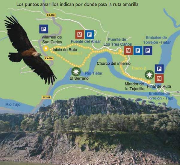
The YELLOW route: from Villarreal to Mirador de la Tajadilla
This is an easy route with gentle climbs. You will pass through orchards, pastures and scrubland. The dehesas are fields where holm oaks and cork oaks grow and where animals graze. From the Tajadilla viewpoint you can see griffon vultures, Egyptian vultures and black storks. La Tajadilla is a large wall that separates the Tiétar River from the Tagus. You will see the Charco del Infierno, where the river Tiétar meanders, making a sharp bend. Along the way there are fountains where you can refresh yourself.
Part 1
FROM VILLARREAL TO THE FUENTE DE LOS TRES CAÑOS // DISTANCE: 2.2 KM // DURATION: 45 MINUTES // DIFFICULTY: A COUPLE OF EASY INCLINES
From Villarreal you can take two paths. One path goes up to the heliport, an area for helicopters to land, and follows the stone wall. The other path takes you along the Cañada Real until you pass the huts of Villarreal and arrive at the Huerto del Almez, which features a very large tree. Where the two paths join, a dehesa area begins. From the Fuente del Alisar, the path passes through old eucalyptus fields. You will encounter a second fountain, the Fuente de los Tres Caños. It is a good place to rest.
Part 2
FROM LA FUENTE DE LOS TRES CAÑOS TO TAJADILLA // DISTANCE: 2.3 KM // DURATION: 45 MINUTES // DIFFICULTY: SOME RELATIVELY EASY UPHILL CLIMBS
Take the path that leads away from the Fuente de los Tres Caños. The river Tiétar runs at the end of the path. At the Charco del Infierno, where the river meanders, Egyptian vultures nest. This section ends at the Mirador de la Tajadilla viewpoint, where you can see griffon vultures, Egyptian vultures and kites. Return to the Fuente de los Tres Caños by the same route.
DISTANCE: 7,5 KM // DURATION: 2:30 HOURS
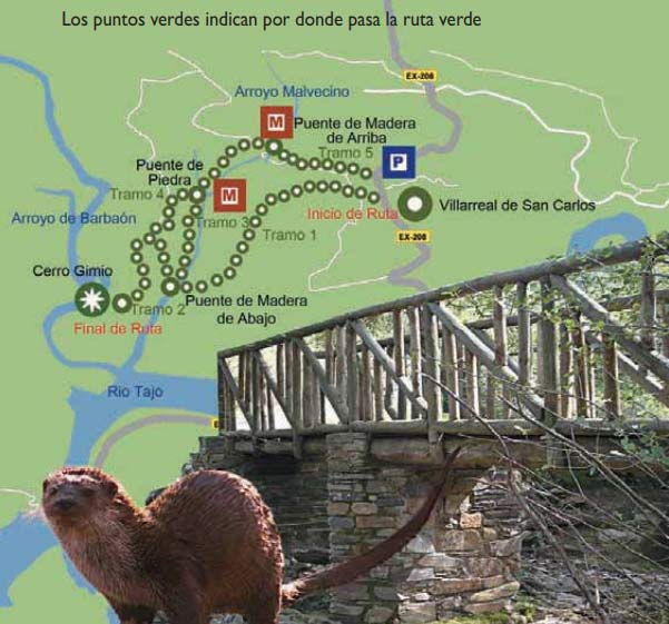
The GREEN route: from Arroyo de Malvecino to Cerro Gimio
This is a long route with abundant riverside vegetation. It follows the course of the Arroyo Malvecino on its right and left banks. Wooden footbridges allow you to cross it without getting wet. From the top of the Gimio Hill you can see the remains of a Roman tower and enjoy beautiful panoramic views of the Salto del Gitano, the Tagus River and the Barbaón and Malvecino streams. Here you may also see the nest of a black vulture.
Part 1
FROM VILLARREAL DE SAN CARLOS TO THE BRIDGE OVER THE MALVECINO STREAM // DISTANCE: 2.8 KM // DURATION: FROM 45 TO 60 MINUTES // DIFFICULTY: EASY DESCENT
At the entrance to Villarreal de San Carlos cross the EX-208 road and continue along a broad path between stone walls that separate fields and properties. 800 metres further down the road there is a turning on the right. Take the marked path that runs along the left side of the Malvecino stream for about 2 km. It ends at a wooden. From there you can choose two options to continue this hike: part 2 or part 3.
Part 2
FROM THE MALVECINO STREAM BRIDGE TO GIMIO HILL // DISTANCE: 1 KM // DURATION: 30 MINUTES // DIFFICULTY: UPHILL PATH WITH A STEEP SLOPE AT THE BEGINNING
From the wooden bridge the path takes you 500 metres up a steep slope to the base of the Cerro. From here, you have to climb another 500 metres along an easier road to the Cerro Gimio viewpoint, which is an excellent spot to take in the landscape of Monfragüe. You can see the remains of a Roman tower, the nest of a black vulture, the Salto del Gitano, the Tajo River and the Barbaón and Malvecino streams.
Part 3
PATH ALONG THE MALVECINO STREAM // DISTANCE: 900 METRES // DURATION: FROM 30 TO 45 MINUTES // DIFFICULTY: EASY PATH WITH WOODEN WALKWAYS
From the lower bridge over the Malvecino you can also take the route along the right bank of the stream. There are many footbridges to cross the stream. The area is cool and pleasant, with riverside vegetation. You can see specimens of ash, strawberry tree and cornicabra. After some twenty minutes you will arrive at another wooden bridge that crosses the stream. On the other side there is a picnic area with tables. To continue the walk, cross the bridge again and follow along the left bank.
Part 4
FROM THE STONE BRIDGE TO THE GIMIO HILL // DISTANCE: 1.5 KM // DURATION: 45 MINUTES // DIFFICULTY: UPHILL WITH MEDIUM GRADIENT
This part starts where part 3 ends and leads up to Cerro Gimio. The walk is easier than in part 2. Before going up, you should have a look at the stone bridge that is a little further on, on the right. It was built using very old techniques. The path leads up to Cerro Gimio on the sunny side of the stream. It has a gentle slope and is 1.5 kilometres long.
Part 5
FROM THE STONE BRIDGE TO VILLARREAL DE SAN CARLOS // DISTANCE: 2 KM // DURATION: 50 MINUTES // DIFFICULTY: EVEN PATH WITH LITTLE INCLINE
From the stone bridge you can return to Villarreal de San Carlos along the right bank of the stream. After about 250 metres you have to cross a small wooden footbridge that leads to a broad path. Follow this path on the right side of the stream to the bridge over the Malvecino stream, 600 metres further on. The bridge is made of wood with slate pillars, and is surrounded by alders and ash trees. It is a cool place where you can rest. The climb up to Villarreal is 1.1 km long and very easy.
Infomation Centers
Information and Tourism Office in Torrejón el Rubio
Plaza de España, 1,
Teléfono: +34 927 45 50 04
Tourist Office in Villarreal de San Carlos
Centro de Recepción e información del Parque Nacional de Monfragüe
Teléfono: +34 927 199 134
Tourist Office in Plasencia
Calle Santa Clara, 4
Teléfono +34 927 423 843
Tourist Office in Trujillo
Plaza Mayor, s/n
Teléfono: Tel.:+34 927 322 67
Tourist Office in Cáceres
Plaza Mayor, s/n
Teléfono: +34 927 11 12 22
